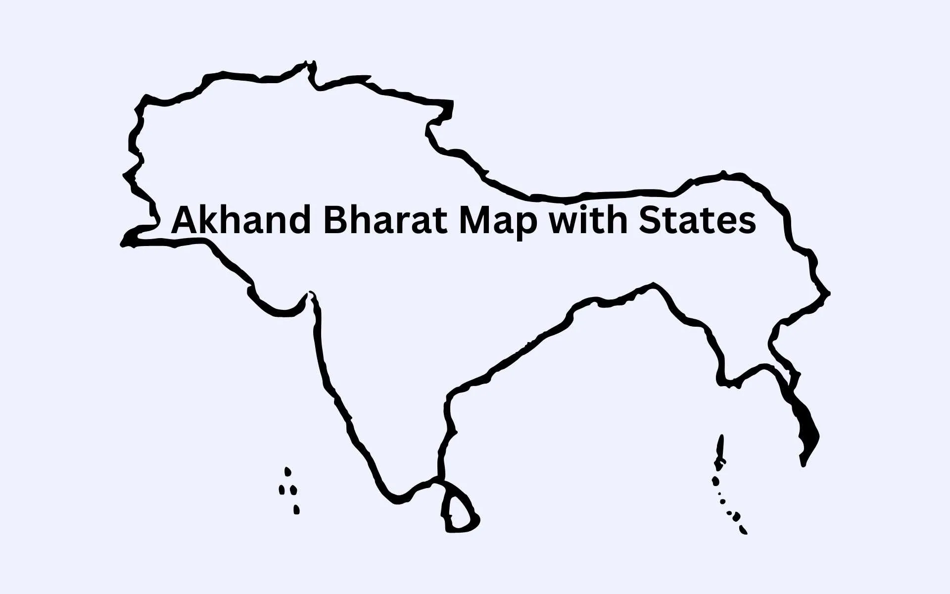
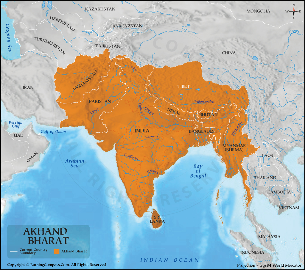
When we talk about Akhand Bharat, all of us visualize the below map. We all know that it comprises present-day India, Pakistan, Nepal, Bhutan, Sri Lanka, Bangladesh, Afghanistan, and sometimes Myanmar and Tibet.
However, most of us also want to know what were the states that made up this political entity. What were its historical provinces, and if there is a concept of Akhand Bharat in the future, what would be its states?
As simple as it seems, it is a very tricky question.
Akhand Bharat does not always mean a political entity or a future projection of Greater India, it also means the cultural sphere of influence of Indian culture (predominantly Hinduism (Sanatani) and Buddhist cultural influence). Hence, we need a broader and multi-dimensional approach.
- Political Akhand Bharat of the Present
- Political Akhand Bharat of the Future
- Cultural Akhand Bharat of the Present
Political Map of Akhand Bharat With States
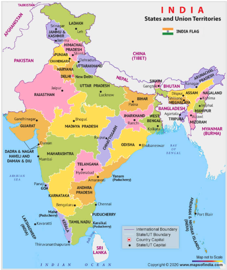
States of the Present Day Akhand Bharat
In its current political context, Akhand Bharat comprises Indian states, Union Territories, and acquired territory in the future (if any). This would mean the following states:
- Assam
- Arunachal Pradesh
- Andaman and Nicobar Islands (UT)
- Andhra Pradesh
- Bihar
- Chandigarh (UT)
- Chhattisgarh
- Delhi (UT)
- Dadra and Nagar Haveli and Daman and Diu (UT)
- Goa
- Gujarat
- Haryana
- Himachal Pradesh
- Jammu and Kashmir (UT)
- Jharkhand
- Karnataka
- Kerala
- Ladakh (UT)
- Lakshadweep (UT)
- Madhya Pradesh
- Maharashtra
- Manipur
- Meghalaya
- Mizoram
- Nagaland
- Odisha
- Puducherry (UT)
- Punjab
- Rajasthan
- Sikkim
- Tamil Nadu
- Telangana
- Tripura
- Uttar Pradesh
- Uttarakhand
- West Bengal
Four Territories of India still lie in illegal foreign control of Pakistan and China. They are Gilgit-Baltistan (part of Ladakh UT), the Western part of Jammu and Kashmir (part of J&K UT), Shaksgam Valley (part of Ladakh UT) and Aksai Chin (part of Ladakh UT). The integration of these territories lies in the near-term goals of the Indian States, and this would complete the present-day Akhand Bharat.
States of The Akhand Bharat of the Future
In the Future, the need to integrate certain former territories of India into the Indian Union remains paramount to India’s future strategic interests. These could then become part of Future Akhand Bharat (politically).
- Rangpur Region
- Chittagong Hill Tracts
- Southern Sindh (till Karachi)
States of the Cultural Akhand Bharat With Map
Culturally, Akhand Bharat would have to be divided into multiple regions and not states because of cultural homogeneity. There is a constant variation in the Indian Subcontinent of culture. This is why we divided Akhand Bharat into multiple variations depending on the approach.
#DISCLAIMER: This is a classification to understand cultural similarities and not political divisions. This should only be taken for informational purposes. We do not support language or cultural impositions.
First Classification from Rabindranath Tagore’s Jana Gana Mana with Map
- Punjab (entire undivided)
- Sindh
- Gujarat
- Maratha
- Maharashtra
- Goa
- Dravida
- Tamil Nadu
- Telangana
- Karnataka
- Kerala
- Andhra Pradesh
- Utkal (Odisha)
- Banga
- West Bengal
- Tripura
- Vindhya (Madhya Pradesh, some regions)
- Himachal
- J&K
- Himachal Pradesh
- Uttarakhand
- Yamuna & Ganga Doab
- Uttar Pradesh
- Bihar
- Madhya Pradesh (some regions)
Second Classification: Cultural Akhand Bharat With Map
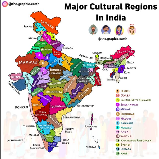
East India
- Odisha
- Kosha
Ganga Plains
- Braj
- Kannauj
- Awadh
- Purvanchal
- Mithila
- Magadh
- Anga
West India
- Kachh
- Saurashtra
- Gujarat
- Konkan
- Bhil
Tamilakam
- Kongu Nadu
- Chola Nadu
- Pandya Nadu
- Thondai Nadu
North Himalayan Cultures
- Himachal
- Lahaul Spiti Kinnaur
- Garhwal
- Kumaon
- Pahari
- Kashmiri
- Ladakh
- Gilgit
- Balti
Panjab Plains
- Doaba
- Malwa
- Majha
- Jammu (Dogri)
- Haryana
- Mewat
Deccan Cultures
- Bastar
- Desh
- Khandesh
- Telangana
- Marathwada
- Vidarbha
Andhra Coast
- Seemandhra
- Rayalseema
- Uttarandhra
Rajputana
- Marwar
- Bagar
- Shekhawati
- Dundhar
Karnataka
- Uttara Karunadu
- Dakshina Karunadu
- Kodagu
Western Ghats
- Konkan
- Malabar
- Tulu Nadu
- Kochi Travancore
- Lakshadweep
Central India
- Mahakoshal
- Nimar
- Malwa (MP)
- Bundelkhand
- Baghelkhand
- Hadoti
Chota Nagpur
- Chhota Nagpur
- Santhal
Bangla
- Rarh
- Bengal
- Kamatpur Rajbongshi
- Sylheti
- Andaman Nicobar
NE Plateaus
- Khasi
- Garo
- Karbi
- Dimasa
East Himalyan
- Sikkim
- Bodoland
- Gorkhaland
- Arunachal
East Him Tribes
- Naga
- Meiti
- Kuki
- Mizo