Akhand Bharat is a geographical area that demarcates the largest extent of Indian influence in history. The areas might be directly under Indian control, or be a part of India’s sphere of influence. Several sources quote several countries as historically being a part of Akhand Bharat with most common countries being, India, Pakistan, Bangladesh, Nepal, Bhutan, Myanmar, Afghanistan and a few other major and minor territories.
Foreign Affairs brings you an comprehensive article about Akhand Bharat so that all your questions about the topic are properly addressed.
Table of Contents
Etymology of The Term
Etymologically Akhand Bharat means “Undivided India”, the world Akhand is used in Sanskrit and several other languages for the term undivided or unbroken.
In 20th century, Akhand Bharat finds mentions in the literary works of Vinayak Damodar Savarkar (Veer Savarkar). In his book “Hindutva, Who is a Hindu?”, Savarkar briefs
Historical Concept of Akhand Bharat
India always existed as a cultural entity since the Indus Valley Civilization. The evidence of such cultural, trade and societal unity can be seen from several sources.
- In the Indus Valley Civilization(IVC), the ratio of brick sizes(1:2:4) was uniform. This only happens when there exist some units of standardization which is only possible in a borderless economy. Contrastingly, in ancient Rome, the brick sizes varied a lot.
- The prevalence of similar town planning in multiple IVC cities. There existed an upper part of town(citadel) and a lower part of town. Further, there was an impressive drainage in all towns of the civilization.
Ancient History
Many ancient texts do mention the concept of Akhand Bharat but use different terms to denote it.
Modern History
The concept made prominence especially during the Indian Independence Movement when a divided India appeared powerless against the British. The need to unite India was felt to raise a united voice against British Rule.
The concept of an united India was popularized because it already existed as a part of Hinduism and ancient Indian texts.
1. Vinayak Damodar Savarkar
In the contemporary period (20th century onwards) Akhand Bharat was a concept shown by people who opposed the partition of India. One such proponent was the freedom fighter Veer Savarkar (full name Vinayak Damodar Savarkar).
Savarkar’s concept of Akhand Bharat was simple, he mentioned the areas as from Sindh to Assam and from Kashmir(referring to princely state of Jammu and Kashmir) to Rameswaram (in modern day Tamil Nadu). Before the formation of new states in north eastern India, Assam was a continuous geography encompassing the enture north eastern India.
2. Kanaiyalal Maneklal Munshi, also known as Ghanshyam Vyas
Munshi was a freedom fighter, lawyer and a writer from Gujarat. He coined the idea of “Akhand Hindustan” to oppose the demand for a separate nation by the Muslim League.
Munshi was elected as a member of Bombay Presidency Legislative assembly in 1927 but resigned after Gandhi’s influence during Bardoli Satyagraha. He served as he Home Minister of Bombay Presidency after the 1937 elections.
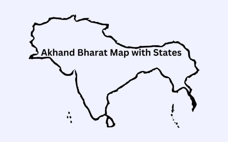
Areas of Akhand Bharat
The areas vary from map to map and source to source because there hasn’t been a consensus of exactly what would constitute Akhand Bharat.
This causes confusion especially creating maps.
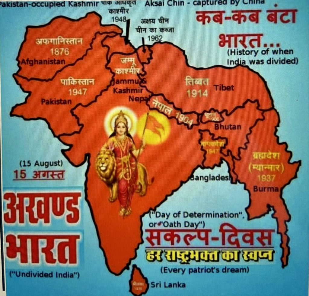
1. Afghanistan
Present-day Afghanistan has a rich history of association with India. During Indus Valley civilization, it used to be the uppermost extent of the Indus-Valley culture.
2. Tibet
Tibet has been a very old trading partner of India. The present day region of Tibet was a trade partner of Kingdoms present in India. Further, Buddhism also links Tibet to India, since the country was a Buddhist theocratic state before its annexation into China.
3. Pakistan
Pakistan was a part of India since the Indus Valley Civilization and had been a continuous part of India till its partition by the British Govt in 1947.
4. Bangladesh
Similarly, Bangladesh was also a part of India before its partition in 1947. Bangladesh also has cultural and linguistic links with India
5. Nepal
Nepal however, existed as an independent Kingdom with varying degrees of British influence over time. But, culturally, it is the closest country to India in the present age with a dominant Hindu populations and a lot of shared traditions.
Maps
There has been no consensus, nor any major exercise to arrive at an consensus regarding the map of Akhand Bharat. This results in several versions of maps that include different regions, often without much evidence.
We have also presented maps of Akhand Bharat from the RSS, which had been a long proponent of the concept.
1. Generally Accepted Maps
Below are the maps that are generally accepted as Akhand Bharat. However, due to a lack of a consensus, there appears to be some territories that change from map to map.
For example, several maps add the earlier Srivijaya Empire due to its historical links with the Chola Empire, which does not find a place in Akhand Bharat’s Map by RSS or Savarkar.
Version 1
This version of Akhand Bharat focuses more on the Indian subcontinent and includes territories where the former British India along with Tibet and Afghanistan.
All the regions shown in the map once formed a part of India and still have significant cultural links with India.
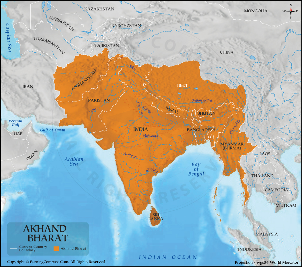
Note: The following map was sourced from burning compass, which is a website to create maps.
2. RSS Map of Akhand Bharat
RSS has very detailed literature on Akhand Bharat. Several of its member have published books where they have mentioned the complete picture of Akhand Bharat along with historical and literary sources to justify such claims.
“One prayer views her as the land of seven sacred rivers from the Sindhu or Indus to the Cauvery, from the Ganga and Yamuna to the Godavari and the Narmada, the commingling of whose holy waters imparts their collective purity at the indispensable bath before worship,” he said.
“By such a prayer, [a] South Indian is at once united across the barrier of the Vindhyas with his brethren of the North in worshipping what constitutes their common country. Sacred also are the waters of the Kabul (Kubha), of Qoomaal (Gomati), of Kuram (Krumu) and of Swat (Suvastu) on whose banks were sung the hymns of the Rigveda.”
Radha Kumud Mookerjee, RSS Member and Historian, 1945 at Akhand Bharat Conference held in the Lucknow University, Source: https://ia903404.us.archive.org/28/items/akhandbharat035108mbp/akhandbharat035108mbp.pdf
3. 2023 Indian Parliament Map of Akhand Bharat
On 28 May 2023, the Prime Minister, Narendra Modi, inaugurated the new parliament buildings which had been under construction to accommodate more seats for the 2026 Indian Delimitation. The exercise will likely increase the strength of Lok Sabha to about 850 seats which the current parliament can hardly accommodate.
The new parliament building had featured a map of ancient India during the reign of Mauryan Emperor Ashoka. This map raised a lot of objections from neighboring countries of Pakistan and Bangladesh who labeled it as a map of Akhand Bharat.
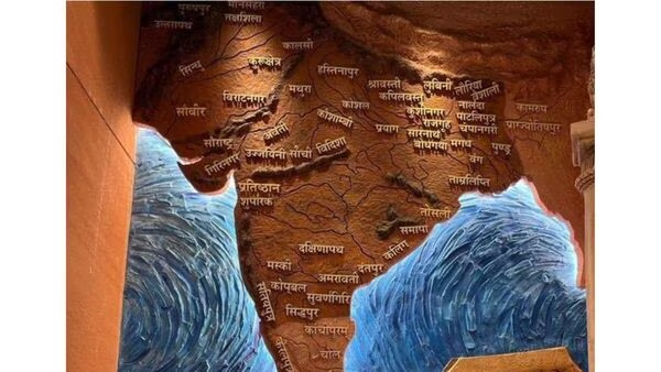
However, you can clearly see the difference in the map of Akhand Bharat and Ashoka’s reign.
- The map in Indian Parliament clearly mentions the areas of Kamrup and Prajyotishpur (believed to be present day Guwahati), both in Assam to be outside of the realm. While Akhand Bharat typically extends even to Myanmar, and in some cases to Malaysia, and Indonesia.
- Further, this map also excludes southern Indian areas of Kanchipuram, areas of then Chola Sovereigns(present day parts of Andhra, Tamil Nadu), and the area of present-day Kerala.
All of these differences clearly indicate that there was a misunderstanding by Pakistani, Nepali and Bangladeshi authorities.
Things were complicated when Indian Minister of Parliamentary Affairs, Pralhad Joshi, tweeted this image and captioned it as Akhand Bharat.